While the commutertory aspects of the snow are somewhat odious I must admit it has been a lovely Winter with many a Currier and Ives vista out our front door.
And many a bottle of warmthifying red wine consumed inside.
So we’ve got another couple inches of Gorebal Warmening as of 4am, and more coming.
As an added bonus we might get a chance to an icy sleety rain for a few hours before another change back to rain.
Sort of like a white chocolate mousse with no calories.
what’s not to love?
Update: a snowy day here in Evil Capitalismia
I’m not sure what language this is in but it doesn’t sound good
THE DIGGING UPSTREAM DYNAMICS OVER THE CENTRAL PLAINS WILL RAPIDLY CATCH UP WITH THE SRN STREAM DYNAMICS TO POTENTIALLY PHASE OVER THE SERN PORTION OF THE COUNTRY. THIS WILL ALLOW A SIGNIFICANT INCREASE IN MOISTURE ADVECTION FROM THE GULF OF MEXICO AND ATLANTIC TO INTERACT WITH A DEVELOPING COASTAL LOW ALONG THE SOUTHEAST COAST… WHILE ONE OF THE MORE IMPRESSIVE CONFLUENT ZONES ALOFT KEEPS THE ARCTIC AREA OF HIGH PRESSURE ENTRENCHED OVER THE EAST. A TRUE BAROCLINIC LEAF PRECIP SHIELD WILL EVOLVE FEATURING MAJOR ICING FROM ATL TOWARD CAE THEN SHIFTING NORTH TOWARD RDU AND A VERY HEALTHY DEFORMATION ZONE OF BANDING SNOWFALL FROM NRN GA/SWRN NC/NWRN SC NEWRD TO SWRN/CENTRAL VA BEFORE REACHING THE DC/BALT/PHIL METRO AREAS. THE ICE
ACCUMULATIONS REMAIN MIND-BOGGLING IF NOT HISTORICAL WITH ADDITIONAL .50 TO 1 INCH AXIS FROM ATL/AHN/AGS TO CAE TO RDU AND 8 TO 10 INCHES OF SNOW FROM AVL/GSP TO ROA/LYH/CHO AND JUST SOUTH OF IAD/DCA WITH A POSSIBLE FOOT NEAR SWRN NC/NWRN SC. WPC CONTINUEDTHE COMPROMISE OF THE GFS/ECMWF/UKMET WITH SUPPORT FROM THE SREF MEAN FOR THE BEGINNING OF A CLASSIC EAST COAST WINTER STORM.
THEN ON THURS… THE INTENSIFYING SURFACE LOW GOING THROUGH RAPID CYCLOGENESIS WILL TRACK FROM THE OUTER BANKS OF NC TO THE NEW ENGLAND COASTLINE. THIS WILL RESULT IN A WEALTH OF ATLANTIC MOISTURE SURGING INTO THE NRN MID-ATL STATES AND NORTHEAST FOR A NARROW BUT IMPRESSIVE AXIS OF HEAVY SNOWFALL. THE GUIDANCE IS ALL
UNANIMOUS IN A WELL-ESTABLISHED DEFORMATION AXIS/COMMA HEAD OF HEAVY SNOW BUT DIFFER ON THE EXACT CORRIDOR. WPC TOOK A MEAN APPROACH OR TAKING OUT THE SPECIFIC DETAILS AND RESOLUTION OF THE GUIDANCE FOR A HEAVY SNOW AXIS JUST WEST OF THE I95 CORRIDOR FROM DC/BALT AREA TO BOS AND CONTINUING UP INTO MAINE. THE EXACT
AMOUNTS ON THURS ARE STILL SOMEWHAT UNCERTAIN BUT A STRIPE OF 6 TO 12 INCHES WILL BE POTENTIALLY POSSIBLE FROM NERN PA/NWRN NJ THROUGH DOWN EAST MAINE.
I’d better get another case of wine…
So far this Winter we’ve gotten about 48″ of Gorebal Warmening.
Our average is around 15″.
Oh and perhaps another 8-12 due Thursday.
It’s been very lovely.
Sunday night we had a lovely 2 or so inches of fresh fluffy snow, and when I walked out yesterday morning at 4:30 or so to go to work there, prancing about in the pristine whiteness, were 8 deer who seemed rather put out that I would be so cheeky as to disturb their vixen-like dashing and dancing.
From the Extended Forecast page of the National Weather Service
…SENSIBLE WEATHER HIGHLIGHTS…
LIGHT TO MODERATE RAIN/SNOW IN THE WEST WILL TRANSLATE EASTWARD
AND INCREASE IN COVERAGE AS THE SYSTEM DEVELOPS ALONG THE NORTHERN
GULF COAST SAT/D4 INTO THE SOUTHEAST SUN/D5. A WELL-DEFINED SYSTEM
SHOULD MOVE UP ALONG THE COAST AND THEN EXIT NORTHEASTWARD INTO
THE CANADIAN MARITIMES MON/D6 AND WELL INTO ATLANTIC CANADA BY
TUE/D7. PRECIPITATION COULD BE ROBUST… OR COULD BE NEXT TO
NOTHING…FOR SOUTHERN NEW ENGLAND.
They get points for honesty.
…never mind LESS THAN A WEEK APART!!
…WINTER STORM WATCH IN EFFECT FROM TUESDAY MORNING THROUGH
WEDNESDAY MORNING…
.A POWERFUL COLD FRONT WILL MOVE ACROSS THE REGION MONDAY AFTERNOON…BRINGING STRONG NORTHERLY WINDS AND SUBFREEZING
TEMPERATURES INTO THE AREA MONDAY NIGHT THROUGH WEDNESDAY MORNING. A SERIES OF STRONG UPPER LEVEL DISTURBANCE WILL THEN MOVE FROM WEST
TO EAST OVER THE WATCH AREA TUESDAY THROUGH WEDNESDAY MORNING. WITH COLD AIR IN PLACE…MOST OF THE AREA CAN EXPECT A MIX OF FREEZING
RAIN AND SLEET THROUGHOUT THE DAY TUESDAY. THIS MIXED PRECIPITATION TYPE IS THEN EXPECTED TO TRANSITION TO ALL SNOW NORTH OF A LINE FROM
HATTIESBURG MISSISSIPPI TO ANDALUSIA ALABAMA TUESDAY EVENING…AND SOUTH OF THIS LINE ALL THE WAY TO THE COAST AFTER MIDNIGHT TUESDAY
NIGHT. THE TRACK OF THE UPPER LEVEL DISTURBANCE INDICATES THE HEAVIER PRECIPITATION AMOUNTS WILL BE SOUTHEAST OF A LINE FROM WIGGINS
MISSISSIPPI TO GREENVILLE ALABAMA…WHERE SIGNIFICANT HAZARDOUS WINTER WEATHER ACCUMULATIONS ARE POSSIBLE.
ALZ051>064-FLZ001>006-MSZ067-075-076-078-079-270545-
/O.NEW.KMOB.WS.A.0001.140128T1200Z-140129T1500Z/
CHOCTAW-WASHINGTON-CLARKE-WILCOX-MONROE-CONECUH-BUTLER-CRENSHAW-ESCAMBIA-COVINGTON-UPPER MOBILE-UPPER BALDWIN-LOWER MOBILE-
LOWER BALDWIN-INLAND ESCAMBIA-COASTAL ESCAMBIA-INLAND SANTA ROSA-COASTAL SANTA ROSA-INLAND OKALOOSA-COASTAL OKALOOSA-WAYNE-PERRY-
GREENE-STONE-GEORGE-
INCLUDING THE CITIES OF…BUTLER…LISMAN…SILAS…CHATOM…MILLRY…JACKSON…THOMASVILLE…GROVE HILL…CAMDEN…
PINE HILL…HOMEWOOD…MONROEVILLE…EVERGREEN…GREENVILLE…LUVERNE…BRANTLEY…ATMORE…BREWTON…EAST BREWTON…
ANDALUSIA…OPP…MOBILE…PRICHARD…SARALAND…BAY MINETTE…TILLMANS CORNER…THEODORE…DAPHNE…FAIRHOPE…FOLEY…
SPANISH FORT…CENTURY…FLOMATON…MOLINO…FERRY PASS…BRENT…WEST PENSACOLA…BELLVIEW…ENSLEY…MYRTLE GROVE…JAY…PACE…
MILTON…CRESTVIEW…WRIGHT…NICEVILLE…SEMINOLE…EGLIN AFB…WAYNESBORO…RICHTON…BEAUMONT…NEW AUGUSTA…LEAKESVILLE…
MCLAIN…WIGGINS…LUCEDALE
340 PM CST SUN JAN 26 2014
Scheiße!
And here I thought the sleet this afternoon was going to have to suffice.
… Winter Weather Advisory in effect until 8 am CST Saturday…
The National Weather Service in Mobile has issued a Winter Weather
Advisory a mixture of light sleet… light freezing rain and light
snow… which is in effect until 8 am CST Saturday.
* Accumulation… little accumulation is expected over most of the
area but a few slick spots may occur on elevated surfaces such as
bridges and overpasses this evening.
* Impacts… elevated roadways including bridges and overpasses… as
well as exposed metal surfaces… may see minor accumulations this
evening.
Precautionary/preparedness actions…
Although no significant accumulation of sleet or snow is
expected… there is the possibility of some light accumulations
on sidewalks… grassy areas… as well as bridges and overpasses.
The main threat will be during the early evening hours.
Every three years or so, but I’ll take it.
Welcome to Florida!
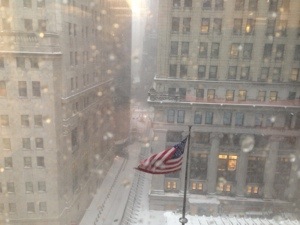
Looks very lovely here on Wall Street.
And I refuse to use schtupid Weather Channel names.
“…Part of the reason that this week’s cold wave did not set any all-time or monthly cold records is that it is becoming increasingly difficult to do so in a warming climate…”
DR. Jeff Masters, WeatherUnderground Blog
You can’t win against the KoolAid.
And -14 with the wind chill.
Really not that cold, but of course I was so bundled up walking to work here in Lower Manhattan that I made the Michelin Man look like Twiggy.
Somebody’s diggin’ the chance to wear his winter threads.
My first question is always, ” And HOW LONG have you lived here?”
Invariably it’s two years or less. Two of the warmer winters we’ve had. Oh, yes. They’re Panhandle winter veterans.
Welcome to a reality check, suckers.
… Wind Chill Advisory in effect from 9 PM Monday to 9 am CST
Tuesday…
The National Weather Service in Mobile has issued a Wind Chill
Advisory… which is in effect from 9 PM Monday to 9 am CST
Tuesday.
* Timing… from 9 PM Monday to 9 am Tuesday.
* Wind chills… as low as zero to 7.
…* Temperature… readings late tonight into Monday morning will drop
as low as the mid 20s well inland to around 30 close to the coast.
Readings late Monday evening into Tuesday morning will drop as low
as 11 to 15 for much of the area except for upper teens near the
immediate coast.
That’s more like it.
You’re either a hero…or a frozen Chinese dinner.
Chinese icebreaker faces trouble after helping in Antarctic rescue
An Australian icebreaker carrying 52 passengers who were retrieved from an icebound ship in the Antarctic was told to halt its journey home on Friday after a Chinese vessel involved in the dramatic rescue became concerned that it, too, may get stuck in the heavy sea ice.
You can’t win against a Warmerist, I’m tellin’ ya.
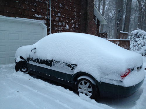
I don’t have to clean all that Gerbil Warmening off her car
And some appreciative handclapping from one of my favoritest peoples on Earth warmed my heart.
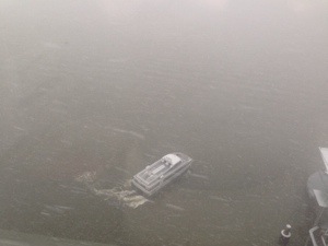
Nanook Ferry Service
My goodness, there will be no love for the Associated Press when the Administration goes through this story
The secret, dirty cost of Obama’s green power push
November 12, 2013 7:18 AM ET
By By DINA CAPPIELLO and MATT APUZZO
CORYDON, Iowa (AP) – The hills of southern Iowa bear the scars of America’s push for green energy: The brown gashes where rain has washed away the soil. The polluted streams that dump fertilizer into the water supply.
Even the cemetery that disappeared like an apparition into a cornfield.
It wasn’t supposed to be this way.
With the Iowa political caucuses on the horizon in 2007, presidential candidate Barack Obama made homegrown corn a centerpiece of his plan to slow global warming. And when President George W. Bush signed a law that year requiring oil companies to add billions of gallons of ethanol to their gasoline each year, Bush predicted it would make the country “stronger, cleaner and more secure.”
But the ethanol era has proven far more damaging to the environment than politicians promised and much worse than the government admits today.
As farmers rushed to find new places to plant corn, they wiped out millions of acres of conservation land, destroyed habitat and polluted water supplies, an Associated Press investigation found.
Five million acres of land set aside for conservation — more than Yellowstone, Everglades and Yosemite National Parks combined — have vanished on Obama’s watch.
Landowners filled in wetlands. They plowed into pristine prairies, releasing carbon dioxide that had been locked in the soil.
All of these subsidies and mandates (and a hell of a lot else, frankly) need to be eliminated and stripped out of that ungodly abomination that the the Farm Bill.
The corrupt alliance between the hyper-regulatory state and agribusiness must be pared back.
And now it’s snowing here in NYC.
I lurves winter.
zoinks
Update: now they are saying it was a quarry blast.
And furthermore just look at the ‘maters!

I planted these things in May and no thanks to Gorebal Warmening Climate Change-inspired cooling Inverted-Warming they still aren’t ripe!
Damn you Bush!

Frack THAT.
Hell, the Century.
Yes, Sharknado was that enjoyable.
Shocking, I know
The US has had wind farms since 1981, what the left and the green movement don’t want to talk about regarding windmills is (as usual) the truth. The truth is: windmills, like solar panels, break down. And like solar panels, windmills produce less energy before they break down than the energy it took to make them. That’s the part liberals forget: making windmills and solar panels takes energy, energy from coal, oil, and diesel, energy that extracts and refines raw materials, energy that transports those materials to where they will be re-shaped into finished goods, energy to manufacture those goods. More energy than those finished windmills and solar panels will ever produce.
But hey, let’s keep dumping money into them because, much like voting for unqualified candidates from particular groups, it makes us feel so good about ourselves.
And self-esteem is all that matters.